다음은 Jeppesen Chart Clinic에서 비행에 실질적으로 필요한 내용만 요약하였습니다.
Chart intro, Legend, Revision cycle
” The Chart Clinic ” Jepp’s Briefing
Enroute Chart
The first enroute charts used by most pilots are the low altitude enroute charts which portray the Victor airways. These low altitude airways are used in the airspace between the minimum usable IFR altitude up to 17,999’ MSL. The high altitude enroute charts display the Jet airways, which begin at 18,000’ MSL and proceed up through FL 450.
최초의 enroute chart는 Victor airway에 기반한 Low altitude enroute charts 였습니다.
To cover the entire United States with low altitude enroute charts, there are 52 charts, even though a subscriber to the full US coverage doesn’t get every one of the 52 charts. These charts are labeled at US(LO)1/2 through US(LO)51/52.
미국 전역의 low altitude enroute charts를 설계하기 위해서 52개주에 해당하는 52개의 차트가 필요했습니다. 이 차트의 라벨은 US(LO) 1/2에서 US(LO)51/52 로 표시되었습니다.
Most of the scales used for the US are 1” = 10 NM, although a few of the charts use the scale of 1” = 20 NM. But, let’s not get too academic. The real reason for mentioning scale is a reminder that when “eyeballing” distances on charts, an inch may represent five minutes on one chart and two and a half minutes on another chart. This can be developed into a “rule of thumbnail:”
Assuming your aircraft flies 300 knots, each nautical mile goes by in .2 minutes. This means that a “thumbnail” measurement on the 20 NM scale chart takes 3 minutes; on the 15 NM scale, a “thumbnail” takes 2 minutes; on the 10 NM scale, a “thumbnail” takes 1.5 minutes. Even though the distances are printed on the charts, there are many times when it is nice to know quickly how far an airport is off an airway, or your time to an intersection.
위 설명처럼 1인치가 10NM 또는 20NM으로 축척을 표시하게 된다.
사실 이처럼 표시하게 된 이유는 다른 이유보다는 조종사들이 쉽게 어림짐작으로 쉽게 계산하기 위해서였다.
예를 들어 항공기가 300 knots 로 비행하고 있다면 1 NM 비행하는데 0.2 분이 소요가 된다. 즉, 10NM 차트에서는 1인치를 비행하는데 2분이 걸리고, 15NM 차트에서는 3분, 20NM 차트에서는 4분이 걸리는 걸 대략적으로 계산할수가 있게 대고 이렇게 공항이나 중간 지점 등까지 얼마가 걸리는 지를 빠르게 계산할 수 가 있던 것이다.
아래 차트 Regend에서 보면 4번 항목이 Chart Scale을 표시한 것이다.
아이파일럿

Chart Layout
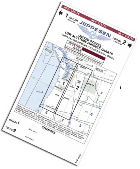
차트 레이아웃은 위아 같이 해당 지역차트에 1,2 번호로 진한 실선의 박스형태로 표시하여 각 차트 페이지로 넘어가는 번호에 대해 화살표로 표시가 되어 있다.
Revision Cycle
If you owned your own VORTAC station and found when tuning to its frequency that you were receiving interference from a neighboring VORTAC, your first reaction would be to change your neighbor’s VORTAC frequency (or your own), effective tomorrow. However, that wouldn’t allow enough time to distribute the new VORTAC frequency to all users of the national airspace system.
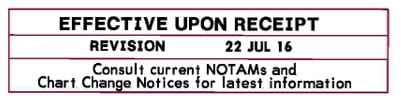
To solve this type of problem, the International Civil Aviation Organization (ICAO) member nations have agreed that at least 42 days of advance notice will be given when major aeronautical changes are made. Not only is the advance notice required, the effective date must fall on “day 1” of a 28-day cycle.
Most of the 184 ICAO nations have agreed to this same cycle. Changes to the enroute charts are effective 0901Z on “day 1,” which always falls on a Thursday.
비행을 하면서 현재 사용하고 있는 VORTAC 기지로부터의 신호가 내일부터 변경될 예정인 같은 주파수의 인접한 VORTAC의 간섭을 받는 경우가 있었다.
이런 문제를 해결하기 위해 ICAO에서 주요 항로 시설의 변경은 최소 42일전에 사전 공지를 하도록 하고 또한 차트 유효기간을 28일로 지정하였다. 184개국의 ICAO 회원국은 이런 Revision Cycle에 동의하였으며 모든 Enroute Charts는 항상 목요일에 그 첫번째 1일이이 되며 시작은 0901Z에 시작한다.
그러나 요즘은 변경이 되었는지 실제로 아래와 같이 차트를 확인해보니 목요일이 아닌 항상 금요일로 변경된 듯합니다.하다.
아이파일럿
Enroute Text Pages
Even though the legend pages aren’t recreational reading, we recommend that you spend a few hours on the next layover reading those “enroute” pages.
본 메거진의 집필자인 “James E Terpstra”는 Enroute Text Page 읽는게 쉽지는 않겠지만 다음 레이오버에서 몇시간을 들여서 학습하기를 권장하고 있다.
실제로 젭슨 차트의 학습이야말로 Professional Pilot의 필수조건이다. 젭슨 텍스트 페이지에는 차트 리딩에 필요한 수많은 정보와 업데이트 정보 그리고 각종 비행규정들이 함께 들어가 있다. 이런 부분을 지속적으로 학습하고 매번 찾아보는 것이야 말로 Professional Pilot이 가져야 하는 습관일 것이다.
아이파일럿
아이파일럿 추가 정보
다음은 젭슨 텍스트 파일인 General (Airway)에 기재된 컨텐츠 목차를 알려드립니다.
아이파일럿
- Preface
- Briefing Bulletins
- Customer Service Bulletins
- Introduction
- Definitions and Abbreviations
- Chart Legend
- Chart Format Description Information
- Signs and Markings
- Visual Docking Guidance Systems(VDGS)
- Chart Change Notices
- Navdata change Data
- Enroute
- Enroute data-General
- Radio Aids
- Radio Data – General
- Meteorology
- Meteorology Service for International Air Navigation
- Meteorological Operational Telecommunications Network – Europe(RODEX) Broadcast Information
- Tables and Codes
- Tables and Codes – Reference Information
- NOTAM Reference Information
- Radio Frequency and Time Information
- Sunrise and Sunset Tables
- Dialing Codes
- True Track Tables
- Air Traffic Control
- Introduction
- International Civil Aviation Organization – Definitions
- International Civil Aviation Organization – Flight Procedures
- International Civil Aviation Organization – Rules of the Air
- International Civil Aviation Organization – ATS Airspace Classfications – ANNEX 11
- International Civil Aviation Organization – TIBA – ANNEX 11
- International Civil Aviation Organization – Air Traffic Management
- International Civil Aviation Organization – Aeronautical Telecommunications – Annex 10
- Air Traffic Management – General Data
- Performance Based Communication and Surveillance(PBCS) – DOC 9869
- Aerodrome Operating Minimums – EASA Air Operations
- Controller Pilot Data Link Communication (CPDLC)
- Emergency
- Emergency Data – International Civil Aviation Authority
- Airport Directory
- Airport Data – General
- Terminal
- Terminal Procedures – General Information
다음 젭슨 차트 클리닉은 "Enroute Chart Legend"입니다.
아이파일럿